
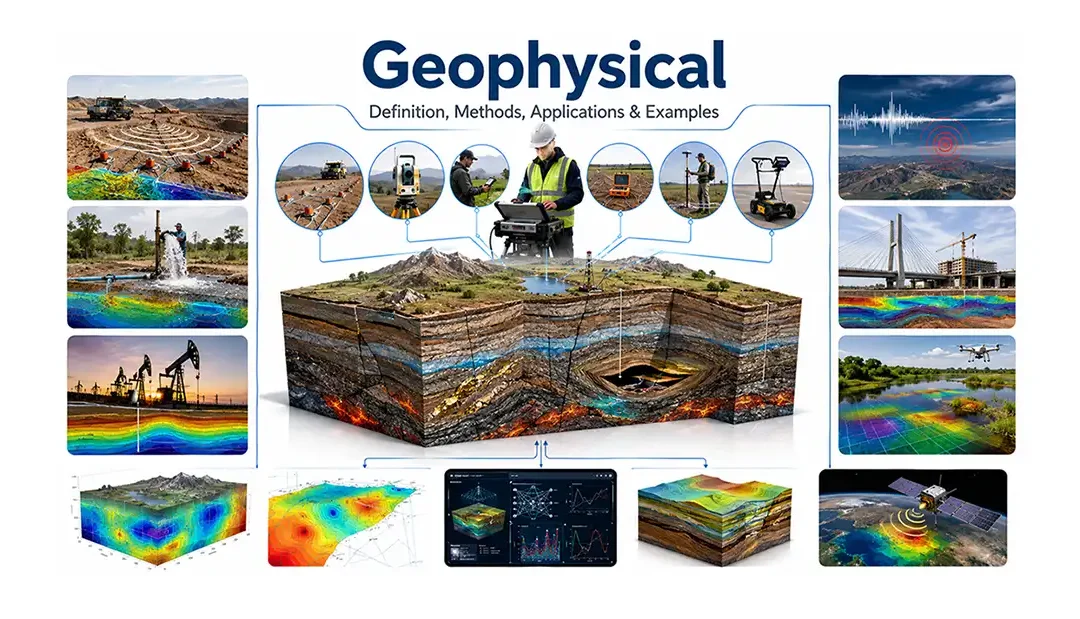
Every day, scientists investigate what lies beneath the Earth's surface without digging deep into the ground. They can locate hidden mineral deposits, detect underground water, map buried faults, and even study the structure of the Earth's interior. Much of this work is possible because of geophysical methods, which use the principles of physics to explore the Earth in a fast, efficient, and non-destructive way.
The term geophysical describes anything related to geophysics, the branch of Earth science that applies physics to understand the planet's structure, composition, and natural processes. Instead of relying solely on visible rock outcrops or drilling, geophysical investigations measure physical properties such as seismic wave velocity, gravity, magnetism, electrical resistivity, and electromagnetic responses. These measurements help scientists build a clearer picture of what lies beneath the surface.
Today, geophysical techniques play a vital role in many fields. They are widely used to discover mineral resources, locate groundwater, explore oil and gas reservoirs, monitor earthquakes and volcanoes, support engineering projects, and assess environmental conditions. As technology continues to advance, geophysical surveys are becoming more accurate, faster, and increasingly important for solving complex geological challenges.
Geophysical Definition
The word geophysical refers to anything related to geophysics, the branch of Earth science that uses the principles of physics to study the Earth's structure, composition, and physical processes. In simple terms, geophysical methods help scientists investigate what lies beneath the Earth's surface without extensive excavation or drilling.
Unlike traditional geological studies, which often rely on direct observation of rocks and landforms, geophysical investigations measure physical properties such as seismic wave velocity, gravity, magnetism, electrical resistivity, and electromagnetic fields. These measurements reveal valuable information about underground rock layers, faults, groundwater, mineral deposits, and other hidden geological features.
For example, before constructing a large bridge or tunnel, engineers often carry out a geophysical survey to understand the subsurface conditions. Mining companies use geophysical techniques to identify potential ore deposits, while hydrologists apply them to locate groundwater aquifers. In earthquake science, geophysical observations help monitor seismic activity and improve our understanding of Earth's interior.
Although the terms geophysical and geophysics are closely related, they do not have the same meaning. Geophysics is the scientific discipline, whereas geophysical is an adjective used to describe methods, surveys, instruments, data, or investigations based on geophysical principles.
Geophysical Methods
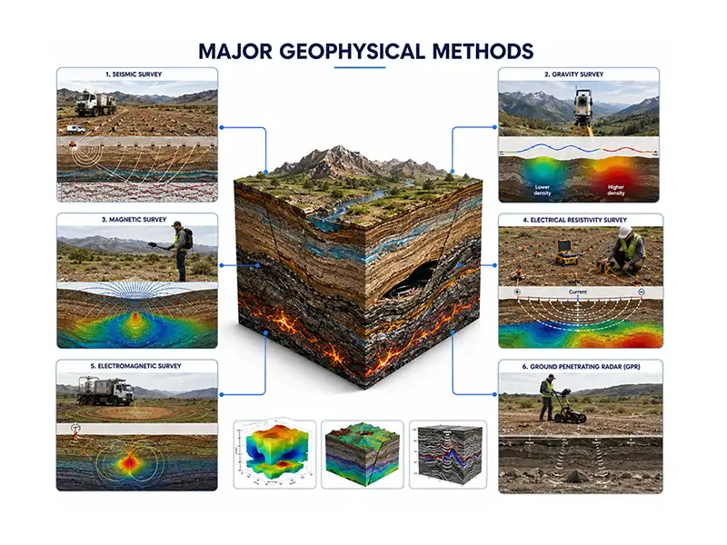
Geophysical methods are techniques used to investigate the Earth's subsurface by measuring its physical properties. Instead of excavating large areas or drilling numerous boreholes, these methods collect data from the ground, water, or air and use it to create an image of what lies beneath the surface. Because they are fast, non-destructive, and cost-effective, geophysical methods have become essential tools in geology, mining, engineering, and environmental studies.
Different methods are designed to detect different physical properties. Some measure how seismic waves travel through rocks, while others detect variations in gravity, magnetism, electrical conductivity, or electromagnetic fields. Choosing the right method depends on the geological conditions and the objective of the investigation.
Seismic Methods
Seismic methods use artificially generated or naturally occurring seismic waves to study underground rock layers. As these waves travel through the Earth, they change speed and direction when they encounter different materials. By recording these changes with sensitive instruments called seismometers or geophones, scientists can determine the depth, thickness, and structure of subsurface formations.
Seismic surveys are widely used in oil and gas exploration, earthquake studies, and engineering investigations because they provide highly detailed images of the Earth's interior.
Gravity Methods
Gravity methods measure tiny variations in the Earth's gravitational field caused by differences in rock density. Dense rocks, such as igneous bodies or metallic ore deposits, produce slightly stronger gravitational attraction than less dense sedimentary rocks.
Using an instrument called a gravimeter, geophysicists can identify underground structures that may contain valuable mineral resources, oil reservoirs, or geological faults.
Magnetic Methods
Magnetic surveys measure changes in the Earth's magnetic field produced by magnetic minerals such as magnetite. These surveys are particularly effective for locating buried igneous rocks, mineral deposits, and geological structures that cannot be seen at the surface.
Magnetic data can be collected from the ground, aircraft, drones, or satellites, making this method suitable for both local investigations and regional geological mapping.
Electrical Resistivity Methods
Electrical resistivity methods determine how easily electrical current passes through underground materials. Different rocks and soils have different resistivity values depending on their composition, moisture content, and porosity.
This technique is commonly used to:
- Locate groundwater aquifers
- Investigate soil and bedrock conditions
- Detect underground cavities
- Assess contamination at environmental sites
Because water conducts electricity better than dry rock, resistivity surveys are especially useful in groundwater exploration.
Electromagnetic Methods
Electromagnetic (EM) methods transmit an electromagnetic field into the ground and measure how subsurface materials respond. Conductive materials, such as groundwater, clay, and metallic minerals, produce different signals than resistive rocks.
These surveys are widely used in mineral exploration, environmental assessments, groundwater investigations, and geological mapping. Since data can often be collected rapidly over large areas, electromagnetic methods are well suited for regional exploration projects.
Ground Penetrating Radar (GPR)
Ground Penetrating Radar (GPR) uses high-frequency radio waves to produce detailed images of shallow subsurface features. When radar waves encounter changes in material properties, part of the signal is reflected back to the surface, where it is recorded and processed into an image.
GPR is particularly effective for investigating shallow depths and is commonly used to locate:
- Buried utilities and pipelines
- Underground voids
- Archaeological remains
- Pavement and road conditions
- Shallow geological structures
Unlike many other geophysical techniques, GPR can produce high-resolution images, making it a valuable tool for engineering, archaeology, and infrastructure inspections.
Geophysical Survey
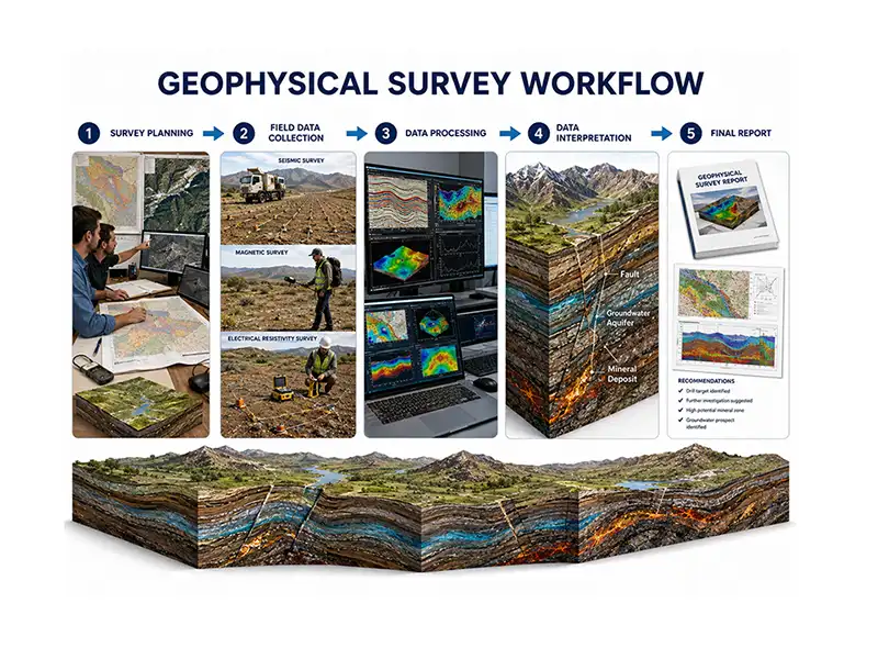
A geophysical survey is a systematic investigation that collects and analyzes physical measurements to understand what lies beneath the Earth's surface. Instead of relying solely on excavation or drilling, geophysical surveys use specialized instruments to detect changes in properties such as seismic wave velocity, gravity, magnetism, electrical resistivity, and electromagnetic conductivity. These measurements allow scientists to map underground structures quickly and with minimal disturbance to the environment.
Geophysical surveys are widely used before major engineering projects, during mineral and groundwater exploration, in oil and gas investigations, and for environmental assessments. By providing valuable subsurface information at an early stage, they help reduce uncertainty, lower exploration costs, and improve decision-making.
Although the equipment and techniques vary depending on the project, most geophysical surveys follow a similar workflow.
Survey Planning
Every successful survey begins with careful planning. Before any fieldwork starts, geophysicists define the project's objectives and study the area's geology, existing maps, satellite imagery, and previous exploration data. Based on this information, they select the most suitable geophysical method and design a survey that provides reliable results.
For example, a groundwater investigation may use electrical resistivity, while mineral exploration often combines magnetic and electromagnetic surveys.
Field Data Collection
Once the survey plan is finalized, technicians collect data using specialized geophysical instruments. Depending on the selected method, measurements may be taken on the ground, from vehicles, aircraft, drones, or even satellites.
During fieldwork, accurate positioning is essential. Modern surveys often use GPS and digital data loggers to ensure every measurement is recorded at the correct location, improving the quality of the final interpretation.
Data Processing
Raw field measurements usually contain unwanted noise caused by environmental conditions, nearby infrastructure, or instrument limitations. Before interpretation, the data must be processed using specialized computer software.
This stage includes correcting errors, removing noise, and organizing the information into maps, profiles, or three-dimensional models. Processing transforms thousands of individual measurements into meaningful geological information.
Data Interpretation
After processing, geophysicists interpret the results by identifying patterns and anomalies within the data. These anomalies may indicate buried faults, groundwater aquifers, mineral deposits, cavities, or changes in rock type.
To improve confidence, geophysical results are often compared with geological mapping, drilling records, and laboratory analyses. Combining multiple sources of information provides a more accurate understanding of subsurface conditions.
Final Report and Decision-Making
The final stage is preparing a technical report that summarizes the survey methods, results, interpretations, and recommendations. Maps, cross-sections, and three-dimensional models are usually included to help clients understand the findings.
Mining companies may use the report to plan drilling programs, engineers may use it to design foundations, and environmental specialists may rely on it to identify contaminated areas or monitor groundwater resources.
Typical Workflow of a Geophysical Survey
| Stage | Purpose |
|---|---|
| Survey Planning | Define objectives and select the most suitable geophysical method. |
| Field Data Collection | Record physical measurements using specialized instruments. |
| Data Processing | Remove noise and convert raw measurements into usable datasets. |
| Data Interpretation | Identify underground structures and geological features. |
| Final Reporting | Present findings, maps, and recommendations for decision-making. |
A geophysical survey is much more than a field investigation. It is a step-by-step scientific process that transforms physical measurements into practical geological information. By reducing the need for unnecessary drilling and excavation, geophysical surveys provide a faster, safer, and more cost-effective way to explore the Earth's subsurface while supporting informed decisions in geology, engineering, environmental management, and natural resource exploration.
Applications in Geology and Earth Science
Geophysical methods have become an essential part of modern Earth science because they allow scientists to investigate the subsurface quickly, accurately, and with minimal environmental disturbance. From locating valuable mineral resources to monitoring natural hazards, these techniques provide information that would be difficult or expensive to obtain through drilling alone.
Today, geophysical investigations support a wide range of industries, helping geologists, engineers, environmental scientists, and researchers make informed decisions based on reliable subsurface data.
Mineral Exploration
One of the most important applications of geophysical methods is mineral exploration. Before drilling begins, mining companies use seismic, magnetic, gravity, and electromagnetic surveys to identify geological structures that may contain economically valuable mineral deposits.
These surveys help locate ores such as iron, copper, gold, nickel, and zinc while reducing unnecessary drilling and exploration costs. By narrowing the search area, companies can focus their efforts on the most promising targets.
Oil and Gas Exploration
The petroleum industry relies heavily on geophysical investigations to locate underground oil and natural gas reservoirs.
Among the available techniques, seismic surveys are the most widely used because they produce detailed images of subsurface rock layers. These images help geoscientists identify geological traps where hydrocarbons may have accumulated over millions of years.
Without geophysical surveys, oil and gas exploration would be far more expensive and less efficient.
Groundwater Exploration
Finding groundwater is another important application of geophysical methods, especially in regions where water resources are limited.
Electrical resistivity and electromagnetic surveys can identify water-bearing rock formations known as aquifers. These methods also estimate groundwater depth, thickness, and quality, helping governments, farmers, and communities develop sustainable water supplies while reducing the number of unsuccessful drilling attempts.
Earthquake Monitoring
Geophysical techniques play a vital role in monitoring earthquakes and understanding the Earth's internal structure.
Networks of seismometers continuously record seismic waves generated by earthquakes around the world. By analyzing these data, scientists can determine an earthquake's location, magnitude, and depth while improving seismic hazard assessments and supporting early warning systems in some regions.
Long-term geophysical observations also contribute to research on plate tectonics and fault activity.
Environmental Studies
Geophysical methods are widely used to investigate environmental problems without disturbing the ground.
Scientists use these techniques to detect buried waste, monitor landfill sites, identify contaminated groundwater, and assess soil conditions. Because most surveys are non-invasive, they provide valuable environmental information while minimizing damage to natural ecosystems.
Archaeological Investigations
Archaeologists increasingly use geophysical surveys to explore historical sites before excavation.
Ground Penetrating Radar (GPR), magnetic surveys, and electrical resistivity methods can reveal buried walls, roads, foundations, graves, and other archaeological features hidden beneath the surface. This approach helps protect cultural heritage by allowing researchers to identify important structures without unnecessary digging.
The wide range of applications demonstrates why geophysical methods are considered indispensable in modern Earth science. Whether exploring for natural resources, designing safer infrastructure, protecting the environment, or advancing scientific research, these techniques provide accurate subsurface information while reducing costs, saving time, and minimizing environmental impact.
Advantages and Limitations
Geophysical methods have transformed the way scientists investigate the Earth's subsurface. Instead of depending entirely on excavation or drilling, they provide a faster and less disruptive way to collect valuable geological information. However, like any scientific technique, geophysical investigations have both strengths and limitations. Understanding these helps researchers choose the most suitable method for a particular project and interpret the results more accurately.
Advantages
One of the biggest advantages of geophysical methods is that they are non-invasive. Most surveys can be completed without extensive excavation, helping preserve the natural environment while reducing damage to the study area.
They are also cost-effective, especially during large exploration projects. Conducting a geophysical survey before drilling allows companies to identify the most promising locations, reducing unnecessary drilling and saving both time and money.
Another major benefit is their ability to cover large areas quickly. Airborne magnetic surveys, satellite observations, and ground-based investigations can collect vast amounts of data within a relatively short period. This makes geophysical methods particularly useful for regional geological mapping and resource exploration.
Modern geophysical instruments also produce high-resolution subsurface data. When combined with geological mapping and drilling information, these datasets help scientists build reliable models of underground structures and improve the accuracy of exploration projects.
Limitations
Despite their many benefits, geophysical methods do not provide direct evidence of underground materials. Instead, they measure physical properties, which must be interpreted by experienced geophysicists. Different geological conditions can sometimes produce similar geophysical responses, creating uncertainty in the interpretation.
Environmental factors may also affect data quality. Nearby power lines, metal structures, heavy traffic, and natural electromagnetic noise can interfere with certain surveys, requiring additional processing before the data can be interpreted.
Another limitation is the cost of specialized equipment. Instruments such as gravimeters, airborne magnetic systems, and high-resolution seismic equipment require significant investment and regular maintenance. Large surveys also involve trained personnel and advanced software for data processing and interpretation.
Finally, no single geophysical method can answer every geological question. In many investigations, combining several techniques with geological observations and drilling results produces the most reliable interpretation.
Future of Geophysical Technology
Geophysical technology continues to evolve as new scientific instruments and digital tools become available. Today's surveys are more accurate, faster, and capable of producing detailed three-dimensional images of the Earth's subsurface than ever before.
One of the most significant developments is the use of artificial intelligence (AI) and machine learning to process large geophysical datasets. These technologies can identify hidden patterns, reduce interpretation time, and improve the accuracy of geological models.
Drone-based surveys are also becoming increasingly popular. Equipped with lightweight magnetometers, cameras, and other sensors, drones can collect high-quality geophysical data over difficult terrain while reducing survey costs and improving safety.
At a larger scale, satellite-based observations allow scientists to monitor gravity, magnetic fields, land deformation, and tectonic activity across the globe. These datasets support research on earthquakes, volcanoes, groundwater, and climate-related changes.
Another exciting advancement is 3D subsurface modeling, which combines information from multiple geophysical methods into a single digital model. These models help geologists, engineers, and mining companies visualize underground structures more clearly and make better decisions during exploration and construction projects.
As technology continues to improve, geophysical investigations will become even more precise, supporting sustainable resource exploration, safer infrastructure development, and a deeper understanding of Earth's dynamic processes.
Conclusion
Geophysical investigations have changed the way scientists explore and understand the Earth. By applying the principles of physics, these methods reveal valuable information about the subsurface without relying solely on excavation or drilling. From identifying mineral deposits and groundwater resources to supporting engineering projects and monitoring earthquakes, geophysical techniques have become an essential part of modern Earth science.
Each method offers unique strengths, and no single technique is suitable for every situation. Choosing the right approach depends on the project's objectives, geological conditions, and the type of information required. In many cases, combining multiple geophysical methods with geological observations provides the most accurate and reliable interpretation.
As technology continues to advance, innovations such as artificial intelligence, drone-based surveys, satellite observations, and 3D subsurface modeling are making geophysical investigations faster, more precise, and more efficient. These developments will not only improve scientific research but also support sustainable resource management, environmental protection, and safer infrastructure planning.
Whether you are a geology student, researcher, engineer, or simply interested in Earth science, understanding geophysical methods provides valuable insight into how scientists investigate the hidden world beneath our feet.
Geophysical refers to anything related to geophysics, the branch of Earth science that applies the principles of physics to study the Earth's structure, composition, and physical processes.
Geophysical surveys provide accurate subsurface information while reducing the need for unnecessary drilling. They support mineral exploration, groundwater investigations, engineering projects, environmental studies, and natural hazard monitoring.
Geophysical methods are widely used in mining, oil and gas exploration, groundwater management, civil engineering, environmental consulting, archaeology, and earthquake research.
Yes. Techniques such as electrical resistivity and electromagnetic surveys are commonly used to identify groundwater aquifers, estimate their depth, and evaluate suitable locations for water wells.
Most geophysical methods are considered non-invasive because they collect information without extensive digging or drilling. This makes them environmentally friendly and suitable for sensitive locations.