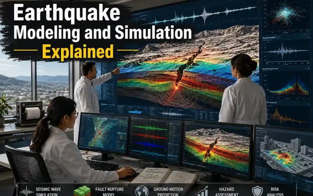
Earthquake modeling and simulation help scientists understand how earthquakes begin, spread, and affect the ground. Using computers, seismic data, and geological information, researchers create digital earthquake scenarios that simulate fault rupture and seismic wave movement.
These models help scientists:
- study earthquake behavior
- estimate future shaking
- identify high-risk zones
- improve building safety
- support disaster preparedness
Modern earthquake simulations are used worldwide to better understand seismic hazards and prepare communities for future earthquakes.
Learn more → plate tectonics and earthquakes
Main Uses of Earthquake Modeling
Main Uses of Earthquake Modeling
How scientists and engineers use earthquake simulation systems.
What Is Earthquake Modeling?
Earthquake modeling is the scientific process of simulating earthquakes using computer systems and geological data.
Scientists create models to study:
- tectonic plate movement
- fault behavior
- stress buildup
- seismic wave propagation
These simulations help researchers understand how earthquakes may behave in the future.
How Earthquake Simulations Work
Earthquake simulations combine:
- seismic records
- fault maps
- rock properties
- tectonic movement data
Computers then calculate:
- fault rupture patterns
- seismic wave movement
- ground shaking intensity
Simulations recreate earthquake scenarios digitally.
Fault Rupture Modeling
Scientists model how faults break during earthquakes.
These models study:
- rupture speed
- fault slip
- stress release
- earthquake energy distribution
Fault simulations help explain:
- why some earthquakes become massive
- why shaking differs between regions
Learn more → crust movement and stress buildup
Seismic Wave Simulation
Earthquake simulations also track seismic wave movement
Scientists study:
- P waves
- S waves
- surface waves
These simulations show:
- how waves travel underground
- how shaking spreads across cities
- which areas may experience stronger shaking
Learn more → earthquake wave types explained
Why Local Geology Matters
| Ground Type | Typical Shaking Effect |
|---|---|
| Solid bedrock | Lower amplification |
| Soft sediment | Stronger shaking |
| Wet soil | Liquefaction risk |
| Coastal sediment | Extended shaking |
Earthquake simulations often include local geology to improve accuracy.
Ground Shaking Simulation
Scientists simulate:
- building vibration
- shaking intensity
- wave amplification
- structural stress
These models help engineers design:
- earthquake-resistant buildings
- safer bridges
- stronger infrastructure
Learn more → earthquake safety in buildings
Tsunami Modeling
Some simulations study tsunami generation
Scientists model:
- seafloor movement
- ocean displacement
- tsunami wave speed
- coastal flooding patterns
These systems improve:
- tsunami evacuation planning
- coastal hazard forecasting
Learn more → subduction zones explained
Earthquake Scenario Simulations
Governments and scientists create earthquake scenarios
These simulations estimate:
- possible earthquake damage
- infrastructure failure
- casualty risk
- emergency response challenges
Scenario modeling helps cities prepare for future disasters.
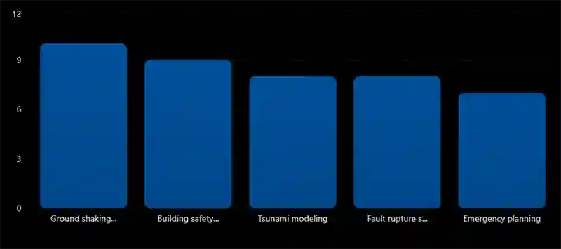
Modeling Different Earthquake Magnitudes
Earthquake Magnitude vs Ground Impact
Larger modeled earthquakes produce dramatically stronger shaking effects.

Earthquake simulations help estimate possible damage from different magnitudes.
Supercomputers in Earthquake Research
Large earthquake simulations often require supercomputers
These systems process:
- massive geological datasets
- complex seismic calculations
- high-resolution ground motion models
Modern simulations may model billions of calculations per second.
Real Earthquake Simulations
| Earthquake Scenario | Purpose |
|---|---|
| Cascadia Megathrust | Tsunami preparedness |
| San Andreas Fault | California risk planning |
| Tokyo Earthquake Models | Urban emergency planning |
| Chile Subduction Models | Coastal hazard analysis |
Many major cities use earthquake simulations for preparedness planning.
Earthquake Modeling and Early Warning Systems
Simulation data also improves earthquake early warning systems
Scientists use models to estimate:
- wave arrival times
- shaking intensity
- likely impact zones
Learn more → earthquake early warning systems
Limitations of Earthquake Modeling
Although simulations are powerful:
- Earth’s geology is extremely complex
- fault behavior is difficult to predict perfectly
- exact earthquake timing cannot be modeled precisely
Models provide estimates and scenarios — not exact predictions.
It is the process of digitally simulating earthquake behavior using scientific data.
To study seismic hazards, ground shaking, and disaster risk.
No — simulations estimate possible scenarios, not exact future events.
They improve preparedness, building safety, and emergency planning.
Final Thoughts
Earthquake modeling and simulation are powerful scientific tools that help researchers understand seismic hazards and prepare for future earthquakes.
By combining geological data, fault analysis, and computer simulations, scientists can study how earthquakes rupture faults, spread seismic waves, and affect cities and infrastructure.
Modern earthquake simulations continue improving disaster planning, engineering safety, and global earthquake research.
Start learning here → What is an earthquake?