
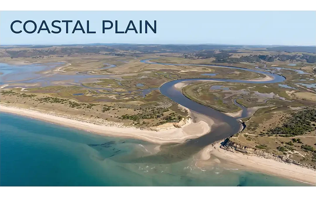
Coastal Plain landscapes form where the land meets the sea, creating broad areas that record the long-term interaction between rivers, waves, tides, sediments, and changing sea levels. Although these landscapes often look simple and flat, their geology can reveal a complex history of shoreline movement, sediment accumulation, erosion, and tectonic change.
Coastal plains occur on many continents and vary widely in size, shape, and geological history. They may contain beaches, rivers, wetlands, dunes, estuaries, tidal flats, and other coastal environments. Their flat terrain also makes many of these areas important for agriculture, settlements, transportation, groundwater, and ecosystems.
At the same time, their low elevation can make them sensitive to coastal erosion, flooding, storm surges, saltwater intrusion, land subsidence, and sea-level rise. Understanding how coastal plains develop and change provides a better view of both Earth's geological history and the challenges facing modern coastal regions.
Coastal Plain:
A coastal plain is a flat, low-lying piece of land adjacent to the coast. It is free from wave action. Coastal plains are separated from the rest of the interior by nearby land areas, such as elevated upland or hillocks and mountains.
The land surface of the coastal plain is very close to the mean sea level (MSL) and sometimes rises only about a few meters above sea level and dips less than one degree. The primary reason for the flat nature of the coastal plain is the unconsolidated sediments that are the "bedrock" of the region.
The Eastern coastal plain refers to a wide stretch of landmass of India, lying between the Eastern Ghats and the Bay of Bengal. It is wider and flatter than the western coastal plains and stretches from Tamil Nadu in the south to West Bengal in the north through Andhra Pradesh and Orissa.
In western South America, the Andes Mountains and the Pacific Ocean surround a large coastal plain. In the United States, you can find coastal plains along the Atlantic Ocean and the Gulf of Mexico.
In the Netherlands and Belgium, the North Sea shaped coastal plains along its edge. Some coastal plains begin as continental shelves—flat pieces of land lying below sea level. When sea levels fall, they expose this land, forming coastal plains. These plains can sometimes stretch far inland.
How Do Coastal Plains Form?
Coastal plains form through several geological processes that work together over long periods. The main processes include sediment deposition, erosion, tectonic movement, and changes in relative sea level.
Sediment Deposition
Rivers are major sources of sediment for many coastal areas. They carry sand, silt, clay, and other materials from inland regions. When the river slows near the coast, some of this material settles and builds new land.
Waves and currents also move sediment along the shoreline. Tidal currents can carry material into tidal flats, estuaries, and other coastal environments. Repeated deposition can gradually create broad areas of low-lying land.
Relative Sea-Level Change
Changes in the position of the land relative to the sea can also shape coastal plains. When the land rises or sea level falls, areas that were once covered by shallow water may become exposed. This process is called coastal emergence.
When the land sinks or sea level rises, seawater can move inland. This process can flood existing lowlands and shift the shoreline toward the land.
Tectonic Movement
Movement of Earth's crust can change the elevation of coastal areas. Uplift can raise coastal land, while subsidence can lower it. These movements can work together with sediment deposition and sea-level changes to shape a coastal plain.
Because these processes can happen repeatedly, many coastal plains contain layers of sediment that record different environments from the past.
Characteristics of Coastal Plains
Coastal plains have several common features, although their exact appearance depends on local geology, climate, sediment supply, and coastal processes.
Low elevation is one of their most important characteristics. Many coastal plains lie close to sea level, although their inland parts may reach higher elevations.
Gentle slopes are also common. Unlike mountainous regions, coastal plains usually have little relief. However, small hills, dunes, river valleys, and terraces can create local changes in elevation.
Sedimentary deposits are widespread in many coastal plains. These deposits may contain sand, gravel, silt, clay, limestone, and other materials. Their thickness and composition depend on the geological history of the region.
Rivers and drainage networks are another common feature. Rivers often cross coastal plains before reaching the sea. Their floodplains, channels, deltas, and estuaries can become important parts of the landscape.
Wetlands and coastal habitats may also occur across low-lying areas. Salt marshes, mangroves, tidal flats, lagoons, and estuaries provide habitats for many plants and animals.
Coastal plains can also preserve evidence of past shorelines and sea-level changes. Old beach deposits, marine terraces, and sediment layers can help geologists understand how the coastline changed through time.
Types of Coastal Plains
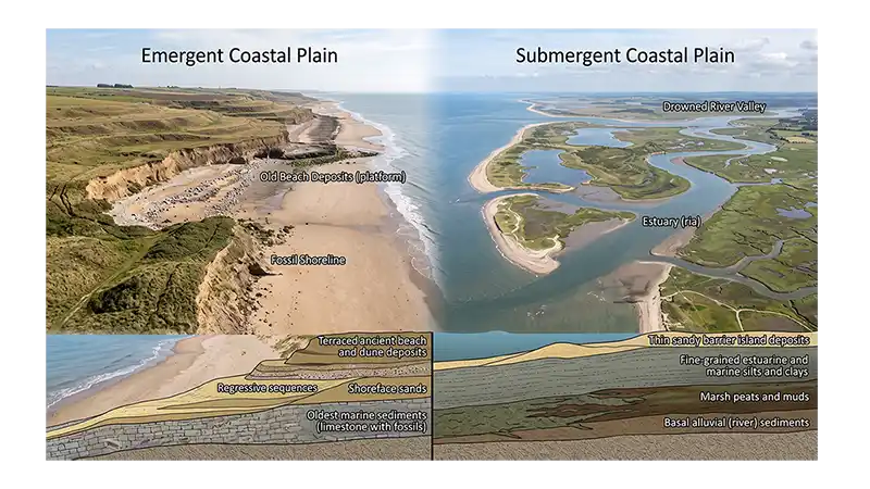
Coastal plains can be broadly described based on how the land and sea change relative to each other over time. Two useful categories are emergent coastal plains and submergent coastal plains. This classification focuses on changes in relative sea level and land elevation, rather than on the type of sediment found on the surface.
Emergent Coastal Plains
An emergent coastal plain develops when the land rises relative to the sea or when relative sea level falls. As the shoreline moves seaward, areas that were once covered by shallow marine water may become exposed. Former beaches, marine terraces, and other coastal deposits can remain on the land as evidence of earlier shoreline positions.
Emergence can result from tectonic uplift, a fall in sea level, or a combination of both. The process may occur gradually over long periods, allowing new coastal land to develop as older marine areas become exposed.
Submergent Coastal Plains
A submergent coastal plain develops when relative sea level rises or when the land moves downward. As seawater advances inland, low-lying areas and river valleys may become flooded. This can create estuaries, bays, tidal wetlands, and other coastal features.
Submergence may result from sea-level rise, land subsidence, or a combination of these processes. Repeated changes can produce layers of sediment that preserve evidence of former coastal environments.
It is important to note that a coastal plain does not always remain entirely emergent or submergent throughout its geological history. A region can experience both processes at different times as land levels, sea levels, and sediment supply change.
Coastal Environments and Zones
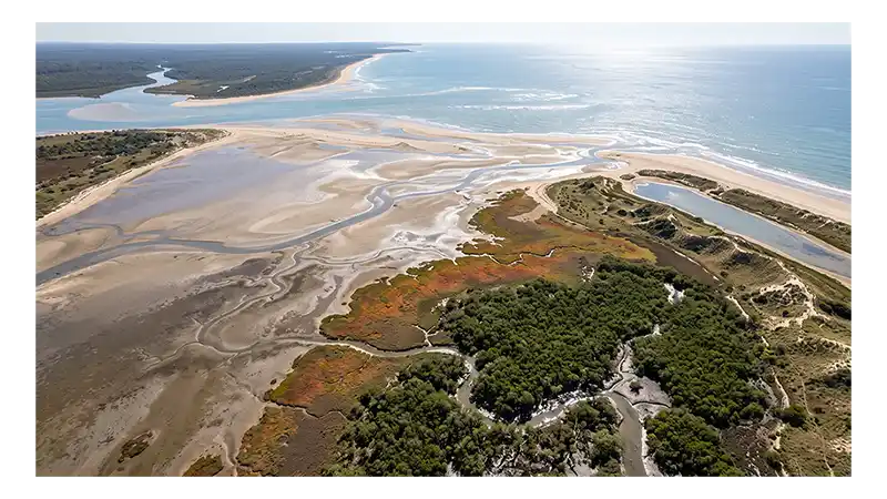
Coastal plains contain a variety of environments where land, freshwater, and seawater interact. Waves, tides, currents, wind, rivers, and sediment supply shape these areas. Their location and features depend on water depth, tidal range, climate, and the amount of sediment available.
The main coastal zones and environments associated with coastal plains include:
| Coastal Environment or Zone | Description | Common Features |
|---|---|---|
| Subtidal Zone | Area that normally remains below the low-tide level | Shallow water, marine sediments, waves, and tidal currents |
| Intertidal Zone | Area between the normal high- and low-tide levels | Regular flooding and exposure, beaches, and tidal flats |
| Supratidal Zone | Area above the normal high-tide level | Occasional flooding during storms or unusually high tides |
| Tidal Flats | Low, flat surfaces that are regularly covered and exposed by tides | Sand, mud, silt, and tidal channels |
| Salt Marshes | Coastal wetlands that receive saltwater regularly or during high-water events | Fine sediment and salt-tolerant vegetation |
| Mangrove Areas | Tropical and subtropical coastal wetlands dominated by mangrove plants | Tidal flooding, muddy sediment, and sheltered shorelines |
| Estuaries | Coastal areas where freshwater mixes with seawater | Brackish water, tidal currents, and rich biological habitats |
| Deltas | Depositional landforms that develop where rivers lose energy and deposit sediment near their mouths | Distributary channels, sediment accumulation, and low relief |
| Coastal Dunes | Mounds or ridges of sand formed mainly by wind near the shoreline | Wind-blown sand and dune vegetation |
| Lagoons | Shallow coastal water bodies partly separated from the open sea | Calm water, barriers, and fine sediments |
These environments are not arranged in exactly the same way on every coastal plain. Local geology, wave energy, tidal conditions, sediment supply, climate, and vegetation determine which environments develop and how they change.
For example, a river may transport sediment across a coastal plain and deposit it near the shoreline, forming a delta. In another area, gentle waves and abundant fine sediment may support tidal flats or salt marshes. In tropical regions, suitable conditions can allow mangrove wetlands to develop along sheltered shores.
Together, these environments form an important part of the coastal landscape and provide evidence of the processes that shape coastal plains over time.
Importance and Environmental Challenges of Coastal Plains
Coastal plains are important because they provide space for human activities and support many natural ecosystems. Their low, relatively flat terrain makes them useful for agriculture, settlements, transportation, and other activities. At the same time, their location near the sea exposes them to several natural and environmental risks.
Importance of Coastal Plains
1. Agriculture and Food Production
Many coastal plains contain broad areas of level land that are suitable for farming. Rivers can also bring water and nutrient-rich sediments to these areas, supporting agricultural activities. However, farming conditions vary depending on soil, drainage, salinity, and climate.
2. Human Settlements and Infrastructure
The gentle terrain of coastal plains makes construction easier in many areas. As a result, towns, cities, roads, railways, and other infrastructure have developed across many coastal lowlands.
3. Ports and Transportation
Their location beside seas and rivers makes some coastal plains suitable for ports and transportation networks. Coastal waterways can support shipping, fishing, trade, and movement of goods.
4. Groundwater Resources
Coastal plains often contain layers of sand and gravel that can store and transmit groundwater. These underground water sources can be important for drinking water, agriculture, and other needs.
5. Wetlands and Biodiversity
Coastal plains can contain salt marshes, mangroves, tidal flats, estuaries, lagoons, and other habitats. These environments support many species of plants, fish, birds, and other organisms. They can also trap sediment, filter water, and reduce some effects of coastal storms.
Environmental Challenges
6. Coastal Erosion
Waves, currents, storms, and changes in sediment supply can remove material from beaches and shorelines. Erosion can gradually change the shape of the coast and threaten buildings, roads, and natural habitats.
7. Coastal Flooding
Many coastal plains have low elevations, making them vulnerable to flooding. Storm surges, high tides, heavy rainfall, and overflowing rivers can cover large areas with water.
8. Sea-Level Rise
Rising sea levels can increase the risk of coastal flooding and shoreline retreat. Low-lying areas may experience more frequent flooding, while wetlands and other coastal habitats may be forced to move inland where enough space is available.
9. Saltwater Intrusion
Saltwater intrusion occurs when seawater moves into freshwater sources near the coast. It can affect coastal aquifers and make groundwater less suitable for drinking or irrigation.
10. Land Subsidence
Land subsidence occurs when the ground surface gradually sinks. Natural sediment compaction and activities such as groundwater extraction can contribute to subsidence in some regions. When the land sinks, the relative sea level becomes higher, which can increase the risk of flooding and saltwater intrusion.
Because coastal plains support both people and ecosystems, understanding their geology and natural processes is important for responsible land use, groundwater management, coastal protection, and environmental conservation.
Examples of Coastal Plains Around the World
Coastal plains occur along many continental margins and vary in size, elevation, geology, and landscape. Some are narrow strips of lowland, while others extend far inland. Their features depend on sediment supply, river systems, tectonic activity, climate, and changes in relative sea level. Some well-known examples include the following:
1. Atlantic Coastal Plain of the United States
The Atlantic Coastal Plain extends along much of the eastern United States, from the New York region southward toward Florida. It forms a broad transition between the higher land inland and the Atlantic Ocean. The region contains extensive layers of sediment, river valleys, wetlands, beaches, and other low-relief coastal features.
2. Gulf Coastal Plain of the United States
The Gulf Coastal Plain surrounds much of the northern Gulf of Mexico and extends across parts of the southern United States. Rivers have deposited large amounts of sediment across the region, creating broad lowlands, floodplains, wetlands, and coastal environments. The Mississippi River and its delta are especially important parts of this coastal landscape.
3. Eastern Coastal Plain of India
The Eastern Coastal Plain lies between the Eastern Ghats and the Bay of Bengal. It is generally broad and includes several large river deltas. Rivers such as the Mahanadi, Godavari, Krishna, and Kaveri transport sediment toward the coast and have helped develop extensive deltaic and coastal lowlands.
4. Western Coastal Plain of India
The Western Coastal Plain lies between the Western Ghats and the Arabian Sea. It is generally narrower than the eastern coastal plain and contains beaches, estuaries, lagoons, and river valleys. The region also includes several important coastal ecosystems and low-lying areas.
5. Coastal Plain of the Netherlands and Belgium
The coastal region of the Netherlands and Belgium forms part of the low-lying landscape bordering the North Sea. Marine processes, rivers, sediment deposition, and long-term changes in sea level have shaped the region. Human activities have also strongly modified the landscape through dikes, drainage systems, reclaimed land, and other coastal defenses.
6. Coastal Plains of Western South America
Low coastal areas occur along parts of the Pacific coast of western South America. Their width varies considerably because the Andes Mountains approach the Pacific Ocean in many places. Where wider lowlands occur, rivers, sediment deposition, and coastal processes help shape the landscape.
These examples show that coastal plains do not have one standard form. Some are broad and heavily influenced by rivers, while others are narrow and closely bordered by mountains. Despite these differences, they share the general characteristics of low relief and a close geological relationship with the sea.
A coastal plain is a relatively flat or gently sloping area of land located next to a sea or ocean. It usually has low relief and may contain sediments deposited by rivers, waves, tides, and other coastal processes.
Coastal plains form through a combination of sediment deposition, erosion, tectonic movement, and changes in relative sea level. Rivers can add sediment, while waves and currents redistribute it along the coast.
Coastal plains are commonly described as emergent and submergent. Emergent coastal plains develop when land rises relative to the sea or relative sea level falls. Submergent coastal plains develop when relative sea level rises or the land subsides.
Coastal plains may contain beaches, tidal flats, wetlands, estuaries, deltas, dunes, lagoons, rivers, and other low-relief landforms. The exact features depend on local geology, climate, tides, waves, and sediment supply.
Coastal plains provide land for agriculture and settlements and support transportation, ports, groundwater resources, wetlands, and diverse ecosystems. However, their low elevation can also make them vulnerable to flooding, erosion, storms, saltwater intrusion, and sea-level rise.
Conclusion
A coastal plain is a low-relief landscape that develops through the long-term interaction of rivers, waves, tides, sediments, tectonic movement, and changes in relative sea level. These processes shape features such as beaches, tidal flats, wetlands, estuaries, deltas, dunes, and lagoons.
Coastal plains are important for agriculture, settlements, transportation, groundwater, and natural ecosystems. However, their low elevation also makes them vulnerable to flooding, erosion, storm surges, saltwater intrusion, land subsidence, and sea-level rise. Understanding their formation and geological history helps us explain past shoreline changes and make better decisions about protecting and managing coastal environments.