
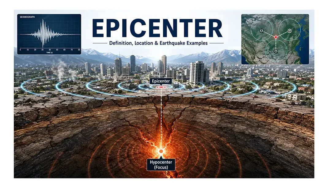
After a major earthquake, one location almost always appears in news headlines—the epicenter. Whether the event strikes beneath a city, a remote mountain range, or the ocean floor, reporters quickly identify the epicenter to show where the earthquake happened. Yet despite hearing the term so often, many people misunderstand what it actually means.
A common misconception is that the epicenter is the place where an earthquake begins. In reality, the earthquake starts deep underground at a point known as the hypocenter, or focus. The epicenter is simply the point on the Earth's surface directly above that underground source. While it isn't the origin of the earthquake itself, it provides a vital reference for mapping seismic events and understanding their potential impact.
For seismologists, the epicenter is far more than a point on a map. It helps reveal which communities were closest to the earthquake, guides emergency responders toward the most affected areas, and supports tsunami warnings when powerful offshore earthquakes occur. Combined with information about an earthquake's depth and magnitude, the epicenter also helps scientists better understand how faults behave and how seismic hazards are distributed around the world.
What Is an Epicenter?
Imagine dropping a stone into a calm lake. The splash begins beneath the surface, but the point you notice first is directly above it, where the ripples spread across the water. An earthquake works in a similar way.
An epicenter is the point on the Earth's surface located directly above the place where an earthquake begins underground. That underground starting point is called the hypocenter, or focus, where rocks suddenly break or slip along a fault and release a tremendous amount of stored energy.
As this energy travels outward as seismic waves, the epicenter marks the surface location associated with that underground rupture. It does not generate the earthquake itself, but it provides the geographic reference that scientists use to describe where the event occurred.
This is why earthquake reports often read, "The epicenter was 25 kilometers northwest of the city." The statement refers to the earthquake's location on the Earth's surface—not the depth at which the fault actually ruptured.
Knowing the epicenter allows scientists to quickly map earthquakes, estimate which regions experienced the strongest shaking, and coordinate emergency response efforts. It also enables researchers to compare seismic activity over time and identify areas where earthquakes occur most frequently.
Where Is the Epicenter Located?
One of the easiest ways to understand an epicenter is to imagine drawing a straight vertical line from the point where an earthquake begins underground to the Earth's surface. The spot where that line reaches the surface is the epicenter.
Because earthquakes originate beneath the ground, the epicenter is always located on the Earth's surface, not underground. Its position depends entirely on where the earthquake's hypocenter (focus) is located below.
For example, if a fault suddenly ruptures 12 kilometers beneath a mountain range, the epicenter will be the point on the surface directly above that rupture. If the same earthquake occurs beneath the ocean floor, the epicenter will be located at the sea surface directly above the underwater hypocenter. This is why earthquake reports often describe an event as occurring "50 kilometers offshore" or "20 kilometers southwest of a city"—they are referring to the epicenter, not the underground source.
Although the epicenter is commonly associated with the strongest shaking, it is not always the area that experiences the greatest damage. The severity of shaking also depends on factors such as earthquake depth, fault movement, local geology, soil conditions, and the quality of nearby buildings. A shallow earthquake beneath soft sediments may cause much greater destruction than a deeper earthquake with an epicenter at a similar location.
Scientists identify the epicenter using data collected from networks of seismograph stations around the world. Once its location is calculated, it becomes the standard reference point used in earthquake maps, scientific reports, and emergency response planning.
Epicenter and Hypocenter Relationship
Understanding the relationship between these two locations is simple:
- The hypocenter (focus) is where the earthquake actually begins underground.
- The epicenter is the point on the Earth's surface directly above the hypocenter.
- They are connected by an imaginary vertical line.
- Every earthquake has one hypocenter and one corresponding epicenter.
This distinction helps explain why seismologists report both an earthquake's depth and its epicenter. Together, these two pieces of information provide a much clearer picture of where the earthquake occurred and how it may affect nearby communities.
Quick Facts
| Feature | Epicenter |
|---|---|
| Position | On the Earth's surface |
| Located Above | The hypocenter (focus) |
| Can It Be on Land? | Yes |
| Can It Be Under the Ocean? | Yes |
| Used For | Earthquake mapping, hazard assessment, and emergency response |
The epicenter is best thought of as the surface address of an earthquake. While the rupture takes place underground, the epicenter provides the geographic location that allows scientists, emergency managers, and the public to quickly identify where the earthquake occurred.
Where Is the Epicenter Located?
One of the easiest ways to understand an epicenter is to imagine drawing a straight vertical line from the point where an earthquake begins underground to the Earth's surface. The spot where that line reaches the surface is the epicenter.
Because earthquakes originate beneath the ground, the epicenter is always located on the Earth's surface, not underground. Its position depends entirely on where the earthquake's hypocenter (focus) is located below.
For example, if a fault suddenly ruptures 12 kilometers beneath a mountain range, the epicenter will be the point on the surface directly above that rupture. If the same earthquake occurs beneath the ocean floor, the epicenter will be located at the sea surface directly above the underwater hypocenter. This is why earthquake reports often describe an event as occurring "50 kilometers offshore" or "20 kilometers southwest of a city"—they are referring to the epicenter, not the underground source.
Although the epicenter is commonly associated with the strongest shaking, it is not always the area that experiences the greatest damage. The severity of shaking also depends on factors such as earthquake depth, fault movement, local geology, soil conditions, and the quality of nearby buildings. A shallow earthquake beneath soft sediments may cause much greater destruction than a deeper earthquake with an epicenter at a similar location.
Scientists identify the epicenter using data collected from networks of seismograph stations around the world. Once its location is calculated, it becomes the standard reference point used in earthquake maps, scientific reports, and emergency response planning.
Epicenter and Hypocenter Relationship
Understanding the relationship between these two locations is simple:
- The hypocenter (focus) is where the earthquake actually begins underground.
- The epicenter is the point on the Earth's surface directly above the hypocenter.
- They are connected by an imaginary vertical line.
- Every earthquake has one hypocenter and one corresponding epicenter.
This distinction helps explain why seismologists report both an earthquake's depth and its epicenter. Together, these two pieces of information provide a much clearer picture of where the earthquake occurred and how it may affect nearby communities.
Quick Facts
| Feature | Epicenter |
|---|---|
| Position | On the Earth's surface |
| Located Above | The hypocenter (focus) |
| Can It Be on Land? | Yes |
| Can It Be Under the Ocean? | Yes |
| Used For | Earthquake mapping, hazard assessment, and emergency response |
The epicenter is best thought of as the surface address of an earthquake. While the rupture takes place underground, the epicenter provides the geographic location that allows scientists, emergency managers, and the public to quickly identify where the earthquake occurred.
How Is an Earthquake Epicenter Located?
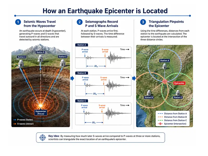
When an earthquake occurs, no one can see the rupture happening deep underground. Instead, scientists locate the epicenter by analyzing the seismic waves recorded at monitoring stations. This process combines precise measurements with well-established principles of seismology, allowing the location of an earthquake to be determined within minutes.
The key to finding an epicenter lies in the fact that different seismic waves travel at different speeds. By comparing when these waves arrive at several monitoring stations, seismologists can calculate where the earthquake originated on the Earth's surface.
Seismographs Record the Earthquake
The first step begins with a network of seismographs, instruments designed to detect even the smallest ground movements.
As seismic waves spread outward from the earthquake's hypocenter, they are recorded by seismograph stations located at different distances from the source. Because each station is positioned in a different location, the waves arrive at different times.
These recordings provide the raw data needed to calculate the earthquake's location.
P-Waves and S-Waves Provide the Distance
Earthquakes generate several types of seismic waves, but two are especially important for locating an epicenter.
- Primary waves (P-waves) travel the fastest and arrive first.
- Secondary waves (S-waves) travel more slowly and arrive a short time later.
The greater the time difference between the arrival of the P-wave and the S-wave, the farther the seismograph station is from the earthquake.
For example, if one station records only a small gap between the two waves, it is relatively close to the earthquake. Another station with a much longer gap is located farther away.
By measuring this difference at multiple stations, scientists can estimate the distance from each station to the earthquake.
Triangulation Identifies the Epicenter
Knowing the distance from one station is not enough because the earthquake could have occurred anywhere along a circle surrounding that station.
To pinpoint the exact location, scientists use a method called triangulation.
Here's how it works:
- Calculate the earthquake's distance from the first seismograph station.
- Draw a circle around that station using the calculated distance as the radius.
- Repeat the process for a second station.
- Add a third station to narrow the possible location.
- The point where all three circles intersect marks the earthquake's epicenter.
In practice, modern earthquake monitoring systems often use data from dozens or even hundreds of seismic stations, allowing computers to determine an epicenter with remarkable speed and accuracy.
Epicenter vs. Hypocenter
The terms epicenter and hypocenter are often used together, and it's easy to see why they cause confusion. Both describe the location of an earthquake, but they refer to two different points.
The hypocenter, also called the focus, is the place deep inside the Earth where the earthquake actually begins. It marks the point along a fault where accumulated stress is suddenly released, causing the surrounding rocks to break or slip. This release of energy generates seismic waves that travel in every direction.
The epicenter, on the other hand, is not underground. It is the point on the Earth's surface located directly above the hypocenter. When scientists or news organizations report the location of an earthquake, they usually describe it using the epicenter because it provides an easily recognizable surface reference.
A simple way to remember the difference is this:
- The hypocenter is where the earthquake starts.
- The epicenter is where that underground point is projected onto the Earth's surface.
For example, imagine an earthquake begins 18 kilometers beneath a coastal city. The rupture occurs at the hypocenter, 18 kilometers below the ground. Directly above it, on the Earth's surface, lies the epicenter. Although both locations are vertically aligned, they represent different parts of the same earthquake.
Understanding this distinction is important because the depth of the hypocenter often influences how strongly an earthquake is felt. A shallow hypocenter may produce intense ground shaking over a relatively small area, while a deeper hypocenter can spread seismic energy across a much wider region. The epicenter simply identifies the earthquake's surface location—it does not indicate how deep the earthquake occurred.
Epicenter vs. Hypocenter Comparison
| Feature | Epicenter | Hypocenter (Focus) |
|---|---|---|
| Location | On the Earth's surface | Beneath the Earth's surface |
| Definition | Surface point directly above the earthquake source | Underground point where the earthquake begins |
| Role | Indicates the earthquake's surface location | Origin of fault rupture and seismic waves |
| Visible on Maps | Yes | No |
| Reported in News | Commonly reported | Usually included with earthquake depth in scientific reports |
| Importance | Mapping, emergency response, and hazard assessment | Understanding earthquake origin and depth |
Although these terms describe different locations, they are inseparable in earthquake science. Every earthquake has one hypocenter, where the rupture begins, and one corresponding epicenter, directly above it on the Earth's surface. Together, they help scientists determine not only where an earthquake occurred but also how it developed beneath the Earth's crust.
Does the Epicenter Always Have the Most Damage?
It's a common belief that the epicenter is always the place where an earthquake causes the greatest destruction. While this is often true for small or shallow earthquakes, it is not a rule. In many cases, the areas that suffer the most severe damage are located some distance away from the epicenter.
Earthquake damage depends on much more than location alone. The depth of the earthquake, the type of fault movement, local ground conditions, and the quality of buildings all influence how strongly the ground shakes.
For this reason, seismologists evaluate several factors before estimating which communities are likely to be most affected.
Earthquake Depth Matters
The depth of an earthquake has a major influence on how seismic waves reach the surface.
- Shallow earthquakes (less than 70 km deep) usually produce stronger ground shaking near the epicenter because the seismic energy has less distance to travel.
- Deep earthquakes may be felt across a much larger region, but the shaking near the epicenter is often less intense.
This is why two earthquakes with the same magnitude can produce very different levels of damage.
Local Geology Can Amplify Shaking
The type of ground beneath a city can greatly affect earthquake intensity.
Soft sediments, river deposits, and reclaimed land tend to amplify seismic waves, causing buildings to shake more violently. In contrast, areas built on solid bedrock often experience less amplification.
As a result, a city located farther from the epicenter may experience stronger shaking than another community that is actually closer.
Building Quality Makes a Difference
The way buildings are designed and constructed often determines how much damage occurs during an earthquake.
Structures built using modern earthquake-resistant engineering generally perform much better than older or poorly constructed buildings. Even if two cities experience similar levels of ground shaking, the one with stronger building codes is likely to suffer fewer collapses and casualties.
Fault Rupture Is Not Always Symmetrical
Earthquakes do not always release energy evenly in every direction.
In some cases, the rupture travels mainly along one section of a fault, concentrating stronger seismic waves in that direction. This phenomenon, known as rupture directivity, can cause communities located away from the epicenter to experience unexpectedly intense shaking.
Real-World Examples
Several well-known earthquakes demonstrate that the greatest destruction does not always occur at the epicenter.
- During the 1985 Mexico City earthquake, severe damage occurred more than 300 kilometers from the epicenter because soft lakebed sediments greatly amplified the seismic waves.
- In many large strike-slip earthquakes, towns located along the direction of fault rupture have experienced stronger shaking than places immediately surrounding the epicenter.
These examples remind us that earthquake impacts are controlled by a combination of geological and engineering factors—not simply by distance from the epicenter.
Famous Earthquake Epicenters
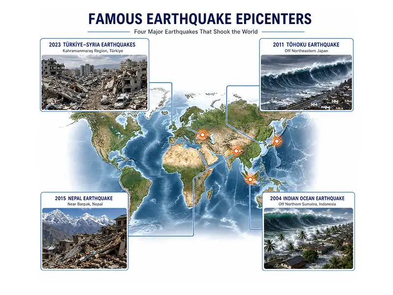
Throughout history, some earthquake epicenters have become well known because of the devastating events associated with them. Studying these epicenters has helped scientists improve earthquake monitoring, understand fault behavior, refine tsunami warning systems, and strengthen building codes in earthquake-prone regions.
While every earthquake is unique, these examples show how an epicenter can influence the extent of an earthquake's impact and provide valuable lessons for reducing future risk.
2004 Indian Ocean Earthquake
On December 26, 2004, one of the most powerful earthquakes ever recorded struck beneath the Indian Ocean. The epicenter was located off the west coast of northern Sumatra, Indonesia.
The earthquake triggered a massive tsunami that spread across the Indian Ocean, affecting countries thousands of kilometers away. More than a dozen nations experienced severe coastal flooding, making it one of the deadliest natural disasters in recorded history.
Scientists used data from this event to improve global tsunami monitoring and establish new early warning systems throughout the Indian Ocean.
2011 Tōhoku Earthquake, Japan
The 2011 Tōhoku earthquake occurred off the northeastern coast of Japan. Its epicenter was located beneath the Pacific Ocean along a subduction zone where the Pacific Plate moves beneath the Okhotsk Plate.
Although the epicenter was offshore, the earthquake generated an enormous tsunami that struck Japan's coastline, causing widespread destruction and triggering the Fukushima Daiichi nuclear disaster.
The event highlighted the importance of rapid epicenter detection for tsunami warnings and emergency response.
2015 Nepal Earthquake
The 2015 Nepal earthquake had its epicenter near the village of Barpak, northwest of Kathmandu.
The earthquake caused extensive damage across central Nepal, destroying historic buildings, triggering landslides, and affecting millions of people. Because it occurred in the Himalayas, the event also provided valuable insights into the ongoing collision between the Indian and Eurasian tectonic plates.
2023 Türkiye–Syria Earthquakes
On February 6, 2023, two major earthquakes struck southern Türkiye near the border with Syria.
The first earthquake's epicenter was near Pazarcık in Kahramanmaraş Province, while a second powerful earthquake occurred later the same day near Elbistan.
The earthquakes caused catastrophic damage across southeastern Türkiye and northern Syria, highlighting the devastating effects that large, shallow earthquakes can have in densely populated regions.
Conclusion
The epicenter is one of the first pieces of information released after an earthquake, but its importance extends far beyond a location on a map. It marks the point on the Earth's surface directly above the earthquake's underground origin, giving scientists and emergency responders a clear reference for where the event occurred.
Knowing the epicenter allows seismologists to map earthquakes, estimate which regions may have experienced the strongest shaking, assess tsunami risks for offshore events, and support rapid disaster response. However, understanding an earthquake requires more than knowing its epicenter alone. Factors such as the hypocenter, earthquake magnitude, depth, fault movement, and local geology all influence how an earthquake affects people and infrastructure.
Whether you're studying geology, preparing for natural hazards, or simply trying to understand earthquake reports, learning about the epicenter provides a solid foundation for understanding how earthquakes are detected, analyzed, and communicated. As seismic monitoring technology continues to improve, the ability to locate earthquake epicenters quickly and accurately will remain essential for protecting lives and advancing earthquake science.
The epicenter helps scientists map earthquakes, assess affected regions, issue tsunami warnings, coordinate emergency response, and study seismic activity around the world.
Seismologists use seismographs (or seismometers) to record seismic waves. Data from multiple stations are combined to determine the epicenter accurately.
Modern global seismic networks can usually locate an earthquake's epicenter within a few kilometers, although accuracy depends on the number and distribution of nearby seismic stations.
Yes. Many earthquakes occur beneath the ocean floor, so their epicenters are located at the sea surface directly above the underwater hypocenter. Large offshore earthquakes can sometimes generate tsunamis.