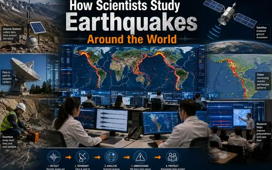
Scientists study earthquakes to understand how and why Earth’s crust suddenly releases energy. By analyzing seismic waves, tectonic plate movement, fault systems, and ground shaking, researchers can learn how earthquakes begin and how they affect different regions.
Modern earthquake science combines:
- seismic instruments
- satellite monitoring
- computer simulations
- geological field research
These tools help scientists:
- monitor active faults
- estimate earthquake hazards
- improve building safety
- support early warning systems
The scientific study of earthquakes is called Seismology
Learn more → what is an earthquake
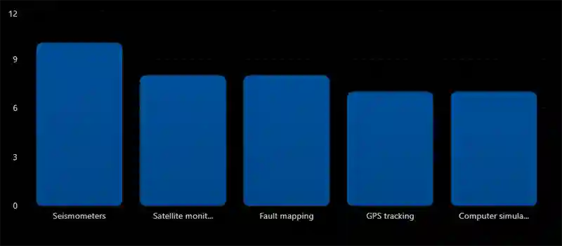
Main Earthquake Research Methods
Main Methods Scientists Use to Study Earthquakes
Key scientific tools and techniques used in modern earthquake research.
Seismology Explained
Seismology is the scientific study of earthquakes and seismic waves.
Seismologists study:
- earthquake causes
- wave movement
- tectonic plate activity
- fault behavior
Their work helps improve:
- earthquake preparedness
- seismic hazard understanding
- disaster response systems
Seismometers and Seismographs
Scientists use seismometers to detect ground movement during earthquakes.
Seismographs record:
- seismic waves
- wave arrival times
- shaking intensity
These recordings help scientists:
- locate earthquakes
- measure magnitude
- study seismic wave behavior
Learn more → how seismographs work
Studying Seismic Waves
Scientists analyze:
- P waves
- S waves
- surface waves
These waves reveal:
- earthquake depth
- epicenter location
- Earth’s internal structure
Wave behavior also helps scientists study Earth’s crust, mantle, and core.
Learn more → earthquake wave types explained
GPS Monitoring and Crust Movement
Scientists use GPS systems to track:
- tectonic plate movement
- crust deformation
- fault displacement
These measurements show where tectonic stress is building underground. Even movement of only a few millimeters can be detected.
Learn more → crust movement and stress buildup
What Scientists Measure During Earthquakes
| Measurement | Purpose |
|---|---|
| Magnitude | Estimate earthquake energy |
| Depth | Understand underground rupture |
| Wave speed | Analyze seismic behavior |
| Fault movement | Study tectonic stress |
| Ground shaking | Assess hazard levels |
Earthquake research combines many types of scientific data.
Fault Mapping and Geological Research
Scientists study fault lines by examining:
- rock layers
- surface cracks
- ancient earthquake evidence
- tectonic landscapes
This research helps identify:
- active seismic zones
- earthquake recurrence patterns
- long-term hazard areas
Learn more → transform faults explained
Satellite Earthquake Monitoring
Satellites help scientists measure:
- ground deformation
- surface displacement
- crust movement after earthquakes
Some satellites can detect tiny changes in Earth’s surface from space. This technology is especially useful after large earthquakes.
Earthquake Simulation and Modeling
Scientists also use computer simulations to model:
- fault rupture
- seismic wave movement
- possible future earthquake scenarios
These models help estimate:
- shaking intensity
- tsunami risk
- structural damage potential
Learn more → earthquake modeling and simulation
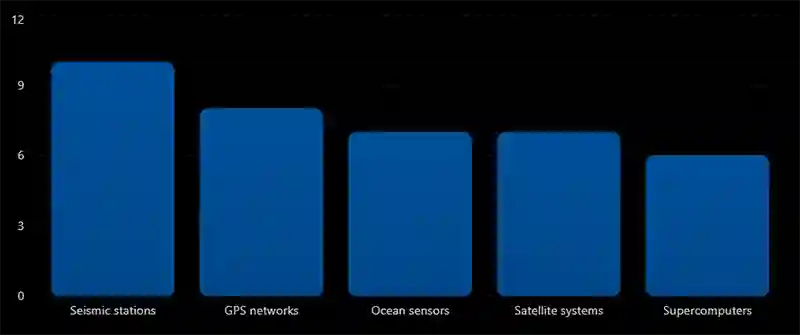
Global Earthquake Monitoring Networks
Global Earthquake Monitoring Systems
Major scientific systems used to monitor earthquakes worldwide.
Ocean Sensors and Tsunami Monitoring
Scientists place instruments beneath oceans to monitor:
- subduction zones
- underwater earthquakes
- tsunami generation
These systems support tsunami early warning networks
Learn more → subduction zones explained
Earthquake Research and Public Safety
Earthquake research helps:
- improve building codes
- strengthen infrastructure
- develop evacuation plans
- improve emergency response
Modern earthquake science plays a major role in disaster preparedness worldwide.
Can Scientists Predict Earthquakes Exactly?
Currently, scientists cannot predict the exact time and location of earthquakes.
However, research helps identify:
- high-risk regions
- active faults
- areas of increasing stress
Scientists continue improving:
- seismic monitoring
- hazard forecasting
- earthquake simulations
Learn more → earthquake prediction methods
It is called seismology.
Seismometers and seismographs detect seismic waves.
Using GPS systems and satellite measurements.
No — exact earthquake prediction is not currently possible.
Final Thoughts
Scientists study earthquakes using seismic instruments, satellite systems, GPS monitoring, geological research, and computer simulations. These tools help researchers understand how earthquakes begin, how seismic waves travel, and which regions face the highest seismic risk.
Modern earthquake science continues improving global preparedness, hazard monitoring, and our understanding of Earth’s constantly moving crust.