Remote sensing is an innovative technique that enables the observation and study of Earth’s features without physical access. Due to its ability to gather information from a distance through the use of satellites, drones, or aircraft, remote sensing has changed coursework in geology, agriculture, and environmental studies.
Remote Sensing:
- It is the science of acquiring, processing, and interpreting images that record the interaction between electromagnetic energy and matter. (Sabins, 1996)
- It is the science and art of obtaining information about an object, area, or phenomenon by analyzing data acquired by a device not in contact with the object, area, or phenomenon under investigation. (Lillesand and Kiefer, 1994).
Types of Remote Sensing:
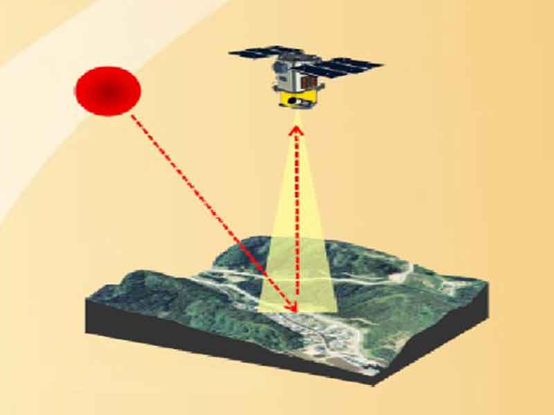
Passive Remote Sensing:
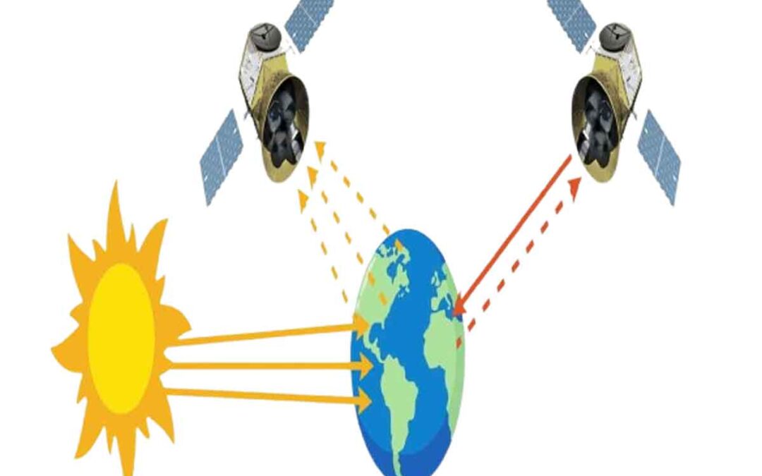
Remote sensing entails assessing the energy that is either reflected or emitted by the Earth’s surface.
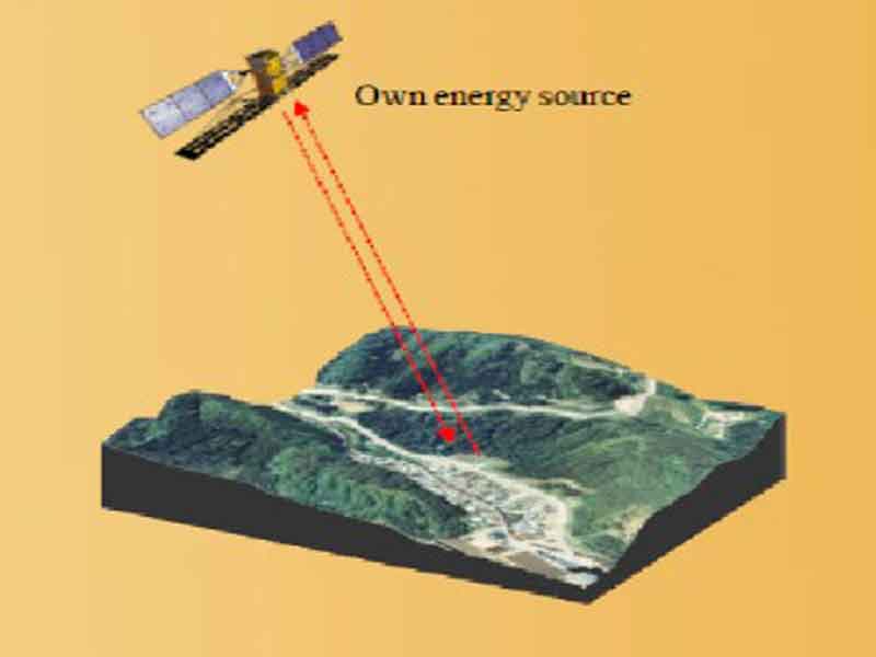
Active Remote Sensing:
Remote Sensing methods use their own source of electromagnetic radiation to illuminate the terrain. Radar is one example.
Applications of Remote Sensing:
Remote sensing applies its varied types of data to a wide range of specific applications. Scientists and researchers mainly use remote sensing for image processing and interpretation. They manipulate air photos and satellite images through image processing to fit various project uses or create maps.
Through image interpretation, researchers can study an area without being physically present. Various fields of study benefit from processing and interpreting remote sensing images. Geologists, for example, use remote sensing to effectively examine and map extensive, hard-to-reach regions.
Geologists rely on remote sensing interpretation to recognize various rock types, geomorphological features, and changes caused by natural events like floods or landslides. Ecologists, physical and biogeographers, agricultural scientists, and foresters use remote sensing to easily detect vegetation in certain areas, assess its growth potential, and determine the conditions supporting its existence.
Urban planners and land-use analysts depend on remote sensing to quickly identify land uses in a specific area. They utilize this data for city planning and studies of species habitats. Remote sensing also plays a vital role in GIS, providing images as input data for raster-based digital elevation models (DEMs) and aiding in GIS digitizing to create polygons. These polygons are then compiled into shapefiles for map creation.
By enabling geographers across various fields to gather, analyze, and manage data from vast, hard-to-reach, or hazardous locations, remote sensing serves as an invaluable resource.
How does remote sensing work?
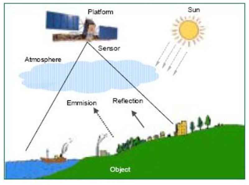
Electromagnetic radiation, whether reflected or emitted by an object, serves as the primary source of remote sensing data. A device designed to detect this radiation is referred to as a “remote sensor” or simply a “sensor.” Common examples of remote sensors include cameras and scanners.
The term “platform” pertains to the vehicle that carries the sensor, with aircraft and satellites often fulfilling this role. By analyzing the electromagnetic radiation that is reflected or emitted from an object, we can determine various characteristics of that object.
Each object exhibits unique traits in its reflection or emission, influenced by factors such as the type of object or the surrounding environment. Remote sensing technology leverages this uniqueness to identify and analyze objects or environmental conditions effectively.
Advantages:
- The Remote Sensing sensor provides a broad perspective.
- Remote Sensing from satellites can be performed repeatedly at a regular time interval.
- Passive Remote Sensing allows us to observe the object or area of interest without causing any disturbance.
- Its data collection can remove the sampling bias introduced in some in situ investigations.
- It provides fundamental biophysical data, x-y location, elevation or depth, temperature, moisture content, etc.
- Remotely sensed data can create DEM.
- Computer processing is possible in many cases.
- It can be conducted in politically or physically inaccessible areas.
Disadvantages:
- Needs ground verification
- Doesn’t offer details
- Not the best tool for small areas
- Needs an expert system to extract data
Limitations:
- The main drawback is that remote sensing is often exaggerated in its capabilities. It isn’t a cure-all that delivers every bit of information necessary for research in the physical, biological, or social sciences. Instead, it offers valuable spatial, spectral, and temporal insights in a way that aims to be both efficient and cost-effective.
- Human beings choose the right remote sensing system to gather data, defining various resolutions of the remote sensor data. They calibrate the sensor, select the platform to carry it, determine the timing for data collection, and outline the data processing methods. However, human error can occur as parameters for the remote sensing instrument and mission are set.
- Active remote sensor systems, like LIDAR, RADAR, and SONAR, that generate their own electromagnetic radiation can sometimes interfere with the very phenomena they are meant to study. Further investigation is necessary to assess the extent of this interference caused by these active sensors.
- Remote sensing instruments can lose their calibration, which can lead to data from remote sensors being uncalibrated.
- Collecting and analyzing remote sensor data may be expensive. Hopefully, the information extracted from the data justifies the expense.
Future Trends in Remote Sensing :
Remote sensing is advancing rapidly, thanks to revolutionary advancements in artificial intelligence, machine learning, and the miniaturization of satellite technology. These enhancements improve data accuracy and boost accessibility, possibly revolutionizing various domains, such as sustainable energy and global health monitoring.
Conclusion :
The ability to see the Earth from a distance through remote sensing is essential in modern research. Remote sensing is also commonly used for environmental protection, urban planning, and a variety of other purposes as well, which goes to show how remote sensing is critical.
Considering the current technological trends one can easily posit that the utilization of remote sensing will advance humanity towards better understanding of Earth and the entire universe. Explore this amazing area of expertise and see how it tackles pressing contemporary challenges!

