Aerial cameras and their use for aerial photography are the simplest and oldest of sensors used for remote sensing of the Earth’s surface. Cameras are framing systems that acquire a near-instantaneous “snapshot” of an area of the surface. The camera uses a lens to focus on reflected light from the real world onto the film.
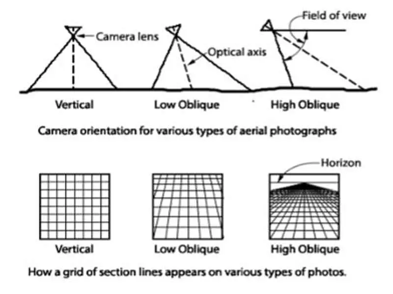
Oblique aerial photography:
Photographs taken at an angle are called oblique photographs. If they are taken from a low angle earth surface- aircraft, they are called low oblique and photographs taken from a high angle are called high or steep oblique.
Vertical aerial photograph:
Vertical photographs are taken straight down. They are mainly used in photogrammetry and image interpretation. Pictures that will be used in photogrammetry are traditionally taken with special large-format cameras with calibrated and documented geometric properties.
Aerial photographs are often combined. Depending on their purpose it can be done in several ways, of which a few are listed below.
Orthophotos:
Vertical photographs are often used to create orthophotos, alternatively known as orthophotomaps, photographs, which have been geometrically corrected to be usable as a map.
Single-lens mapping (metric) cameras:
The lens cone assembly consists of a single, expensive, multiple-element lens.
Multiple-lens (multiple band) cameras:
Photographs taken simultaneously in several regions (bands) of the EM spectrum.
Panoramic cameras:
Use a rotating lens (or prism) to produce a narrow strip of imagery perpendicular to the flight line.
Digital Cameras:
It uses an area array of solid-state charge-coupled device (CCD) detectors.