Rainfall is the primary form of precipitation, and the term rainfall is used synonymously with precipitation.
Precipitation:
Any form of water (or moisture) reaching the ground from the atmosphere is called precipitation, such as rainfall, snowfall, hail, frost, or dew.
Rainfall is the primary form of precipitation, and the term rainfall is used synonymously with precipitation.
Precipitation formation:
- Raising air masses causes moisture to condense.
- Condensation nuclei. Aerosols, water molecules attach
- Rising & Growing
- 0.5 cm/s sufficient to carry 10 μm droplet
- Critical size (~0.1 mm)
- Gravity overcomes and drops fall.
Types of Precipitations:
Cyclonic precipitation:
A cyclone is a vast area of low pressure characterized by winds that swirl around in a circular motion. Tropical cyclones give moderate to excessive precipitation over large areas; extratropical cyclones give low-intensity rainfall over larger areas and longer duration.
Convective precipitation:
A pocket of localized hot air rises and its place is taken by the cooler surrounding air, which sets up a convective cell. The warm air continues to increase, undergoes cooling, and results in precipitation. Lighter showers to thunderstorms can result in a small area.
Orographic precipitation:
The humid air can rise to higher elevations because a mountain range acts as a barrier. Consequently, it undergoes cooling, condensation, and precipitation. Windward slopes, heavy rainfall, leeward slopes, light precipitation.
Forms of Precipitation:
The two most widely recognized types of precipitation are:
Rain:
Rain is the precipitation of liquid water in which drops are generally larger than 0.5 mm.
Snow:
Precipitation is in the form of ice crystals, more often aggregates of ice crystals).
Other forms include:
Sleet:
when raindrops are frozen while falling through a layer of subfreezing air turn into transparent globular
grains of ice between 1-4 mm in diameter.
Glaze (or freezing rain):
Ice coating happens when rain or drizzle freezes upon encountering cold surfaces or objects on the
ground.
Hail:
Precipitation occurs in ice pellets or irregular chunks that are more significant than 5 mm in diameter.
Rime:
A layer of ice crystals develops when supercooled fog or cloud droplets freeze upon surfaces that are below freezing temperature.
Drizzle:
fine sprinkle of very small (0.1-0.5 mm) and uniform water drops.
Dew:
forms directly by condensation on the ground, mainly at night when the outgoing radiation has cooled the surface.
Mist:
smallest water droplets visible
Gaupel:
watery hail
Precipitation Measurements:
- Precipitation is quantified by the depth of water that would accumulate on a surface if all the rain were gathered there, typically expressed in millimeters (mm).
- Precipitation is gathered and quantified using a rain gauge, which is also referred to as a pluviometer, ombrometer, or hygrometer.
Radar Precipitation Measurements:
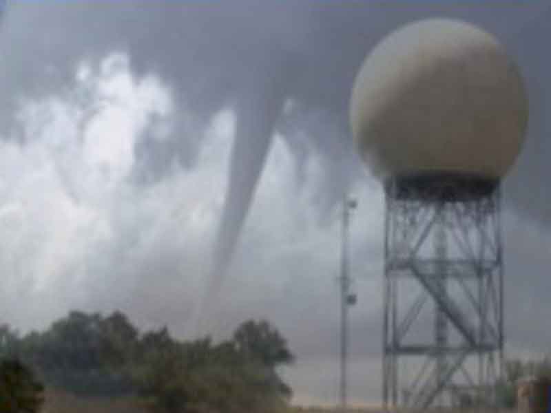
- Enhances ground or point measurement methods that are significantly affected by the issue of under-sampling.
- Provides complete areal coverage and timely reporting
- Used to estimate raindrop concentration in the atmosphere from the strength of the returned signal
- The analysis depends on certain assumptions regarding the distribution of raindrop sizes and their rate of descent.
Precipitation Variation:
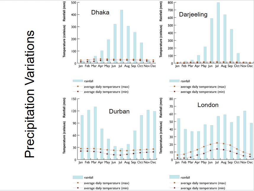
Influenced by Atmospheric circulation and local factors
- Higher near coastlines
- Annual fluctuations in certain regions due to seasonal changes.
- Variables in mountainous areas
- Increases in plains areas
Methods for Estimation of Effective Depth of Precipitation:
- Arithmetic Average
- Thiessen Polygon Method
- Isohyetal Lines
Arithmetic Average:
The Arithmetic Mean Method is the simplest of all the methods. The average result is calculated by taking the total rainfall recorded at all the rain gauges in the area and dividing it by the number of stations.
Pa = 1/N ∑ Pi , (13.97 + 22.1 + 59.2 + 48.0+ 137.2)/5 = 56.1
Applicable when:
- Gauges are uniformly distributed
- Gage measurements do not vary significantly about the mean
Thiessen Polygon Method:
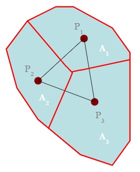
As Mr. A M Thiessen suggested in 1911, Any point in the watershed receives the same amount of rainfall as that at the nearest gage. Rainfall measured at a gauge can be extended to any point halfway to the next station, no matter which direction you look.
Steps in Thiessen polygon method:
- Draw lines joining adjacent gages
- Create perpendicular bisectors for the lines established in Step 1.
- Extend the lines from Step 2 in both directions to outline the representative areas for the gauges.
- Compute representative area for each gage
- To find the areal average, please use the formula provided below.

Isohyetal Lines:
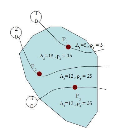
It is to draw lines of equal precipitation (isohyets) on the drainage basin map where the following rules apply:
- Isohyets never cross;
- It never split;
- It never meets;
- A station not directly on an isohyet will be positioned between two.
- The isohyets will either have the same value as the station reading, or one will exceed it while the other falls short.
- Adjacent contours must maintain the same value or differ by only one contour interval.
- It should be scaled between stations using linear interpolation.
Steps:
- Construct isohyets (rainfall contours)
- Compute the area between each pair of adjacent isohyets (Ai)
- Calculate the average precipitation for each pair of neighboring isohyets (pi).
- Calculate the area average with the formula outlined below


